Rolling (Mars) Stone

The 6 meter-wide boulder as imaged by HiRISE (to supersize the pic, click on it - 9MB)

It may only be a large rock, but images like this drive home the significance of the HiRISE instrument on board NASA’s Mars Reconnaissance Orbiter; it enables us to see recent geological activity on a planet we often view as being “dead.”

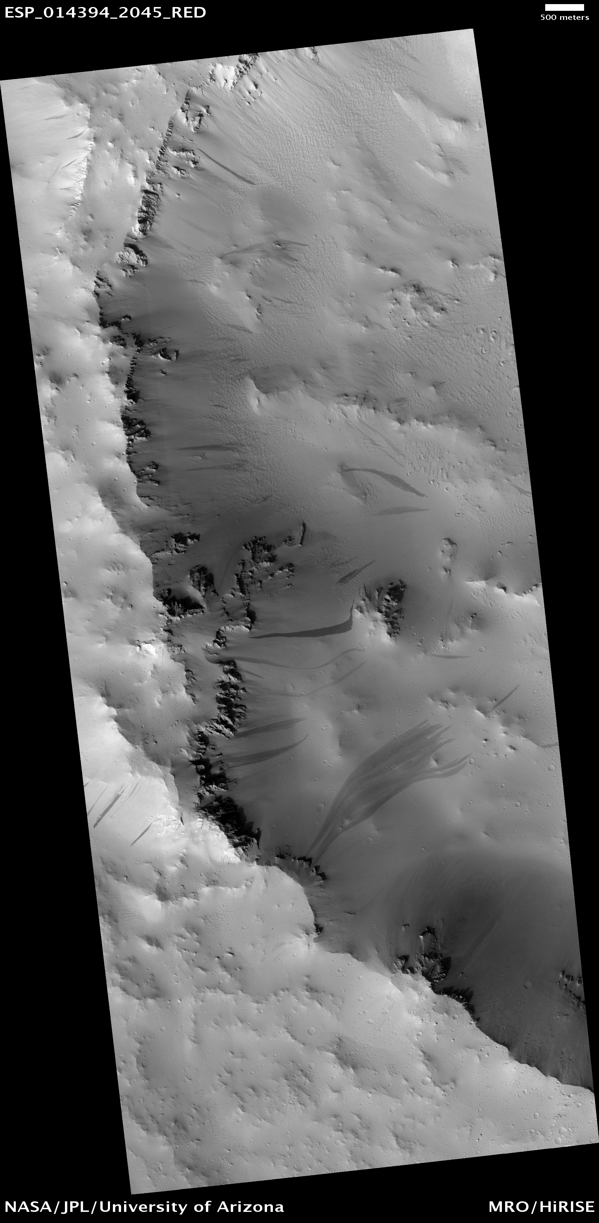
This boulder (approximately 6 meters-wide) had come to a stop at the bottom of the sloping wall of an impact crater. The path the boulder took is obvious as it left a series of prints in the Martian regolith as it bounced and rolled. The darker material that appears to have flowed around the rock is relatively fresh dry dust and sand that has also been dislodged from the top of the slope, falling as an avalanche, settling as a dark streak. As time goes on, the streak will age and blend in with the surrounding regolith.

It is suspected that seismic activity or a weather event (such as a dust devil) may have triggered the avalanche. As for the boulder, it looks like it rolled down the slope before the sand/dust avalanche, so it may have originated from the same destabilization event, or it happened earlier. As the source of the streak and boulder appear to originate from the same location, I suspect the former might be the case.

Regardless, it goes to show Mars is still active, and the MRO is in the perfect location to capture the Red Planet proving that fact.

Source: HiRISE

When Cosmic Rays Attack: The MRO in Safe Mode

mars_reconnaissance_orbiter21

I always get concerned when I hear about one of our invaluable robotic explorers switching into safe mode. This time, it is the turn of NASA’s Mars Reconnaissance Orbiter (MRO) that re-booted itself after an “event” in Mars orbit. It seems likely that a direct cosmic ray hit could be to blame…
Continue reading “When Cosmic Rays Attack: The MRO in Safe Mode”

Frosty Phoenix Not Snowed Under… Yet.

The Mars Reconnaissance Orbiter's HiRISE instrument spots the dead Phoenix Lander on December 21st (NASA/HiRISE)

NASA lost contact with the Phoenix Mars Lander at the start of November 2008, as its batteries were drained and sunlight began to dwindle. With no sunlight came no charge for the batteries from Phoenix’s solar panels, and the robot’s fate was sealed: a sun-deprived coma. A dust storm hastened the lander’s fate, but it certainly wasn’t premature. The Phoenix mission was intended to last three months, but in the same vein as the Mars Exploration Rovers, Phoenix’s mission was extended. In the high latitude location of the Martian Arctic, a dark winter was fast approaching, so Phoenix didn’t have the luxury of time and it transmitted its last broken signal before the cold set in, sapping the last volt of electricity from its circuits…

Although there was some excitement about the possibility of reviving the lander next summer, it is highly unlikely Phoenix will be in an operational state, even if it did have an abundant source of light to heat up its solar panels once more. No, Phoenix is dead.

However, that doesn’t mean the orbiting satellites won’t be looking out for it. So long as there is a little bit of light bouncing off the frosted Martian surface, the Mars Reconnaissance Orbiter can image Phoenix, keeping track of the encroaching ice around its location. The HiRISE team seem to be assembling a series of images throughout the change in seasons at the landing site, so it will be interesting to see the full set…

Source: HiRISE blog

HiRISE Mars Digital Elevation Models: Difficult to Build, Easy on the Eye

DEM images of Columbia Hills on Mars (USGS/HiRISE)

If there’s one instrument that should get the Mars Orbiting Science Award of 2008 it’s the High Resolution Imaging Science Experiment (HiRISE). Flying on board NASA’s Mars Reconnaissance Orbiter (MRO), HiRISE has been taking some astonishing imagery of the Martian surface since 2006. In fact, the HiRISE image gallery has become the staple of my high resolution Mars photo collection, and the studies being carried out by this fantastic instrument have formed the basis of many articles.

However, the most useful images to come from HiRISE are also the rarest. Digital Elevation Models (DEMs) come from the use of stereo image pairs (more commonly seen in anaglyphs generated by the HiRISE team to give the viewer a 3D impression of the Martian landscape). In the case of DEMs, some pretty neat science can be done, generating images of the Red Planet’s terrain in unrivalled precision. Seeing the Victoria Crater DEM is a particular joy
Continue reading “HiRISE Mars Digital Elevation Models: Difficult to Build, Easy on the Eye”