Colonists Beware: Don’t Camp at the Bottom of Martian Hills!

Trails of Mars rocks that have rolled down the slope of a crater rim as imaged by the HiRISE camera. Credit: NASA/JPL/Univ. of Arizona.

It’s always fascinating to see evidence of active geological processes on Mars. And with the help of the armada of robots in orbit and roving the Red Planet, there are plenty of opportunities to see the planet in action.

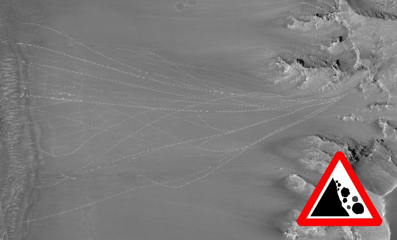
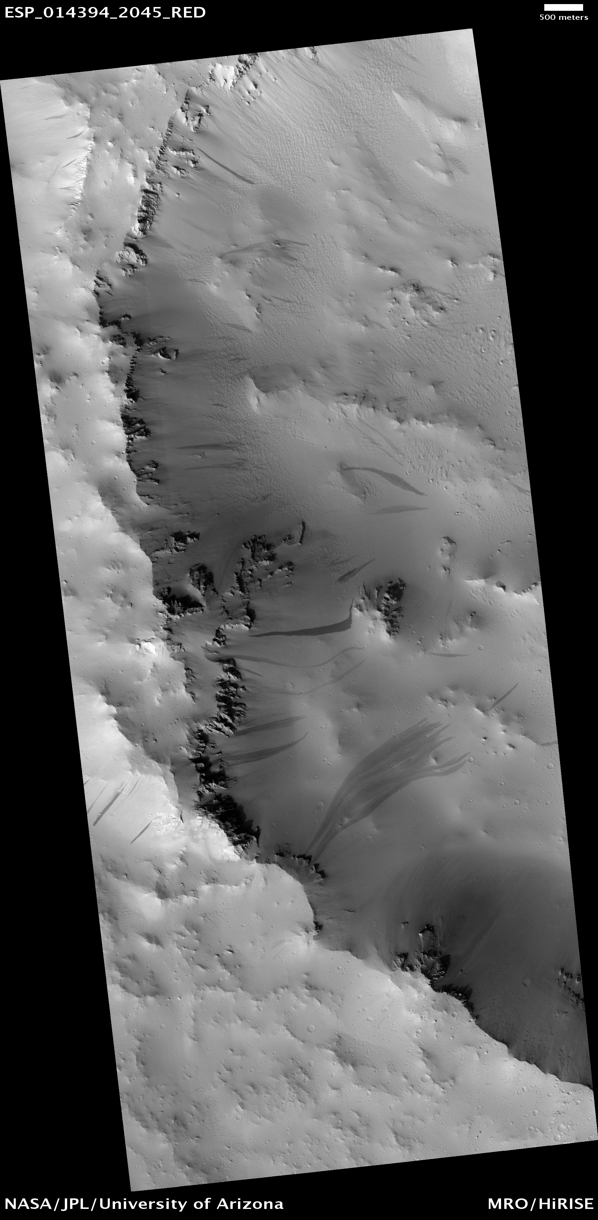
Take this recent image from the High-Resolution Imaging Science Experiment (HiRISE) camera aboard NASA’s Mars Reconnaissance Orbiter (MRO) for example. In this striking scene — which is a little over one kilometer wide — the bright trails of rocks that have rolled down a sloping crater rim after being dislodged from the top are visible from space. The rocks have obviously bounced on their way, leaving dotted impressions as they rolled. Some have reared in wide arcs, following the topography of the landscape. Others have hit other rocks on their way down, dislodging them, creating secondary cascades of smaller boulders.

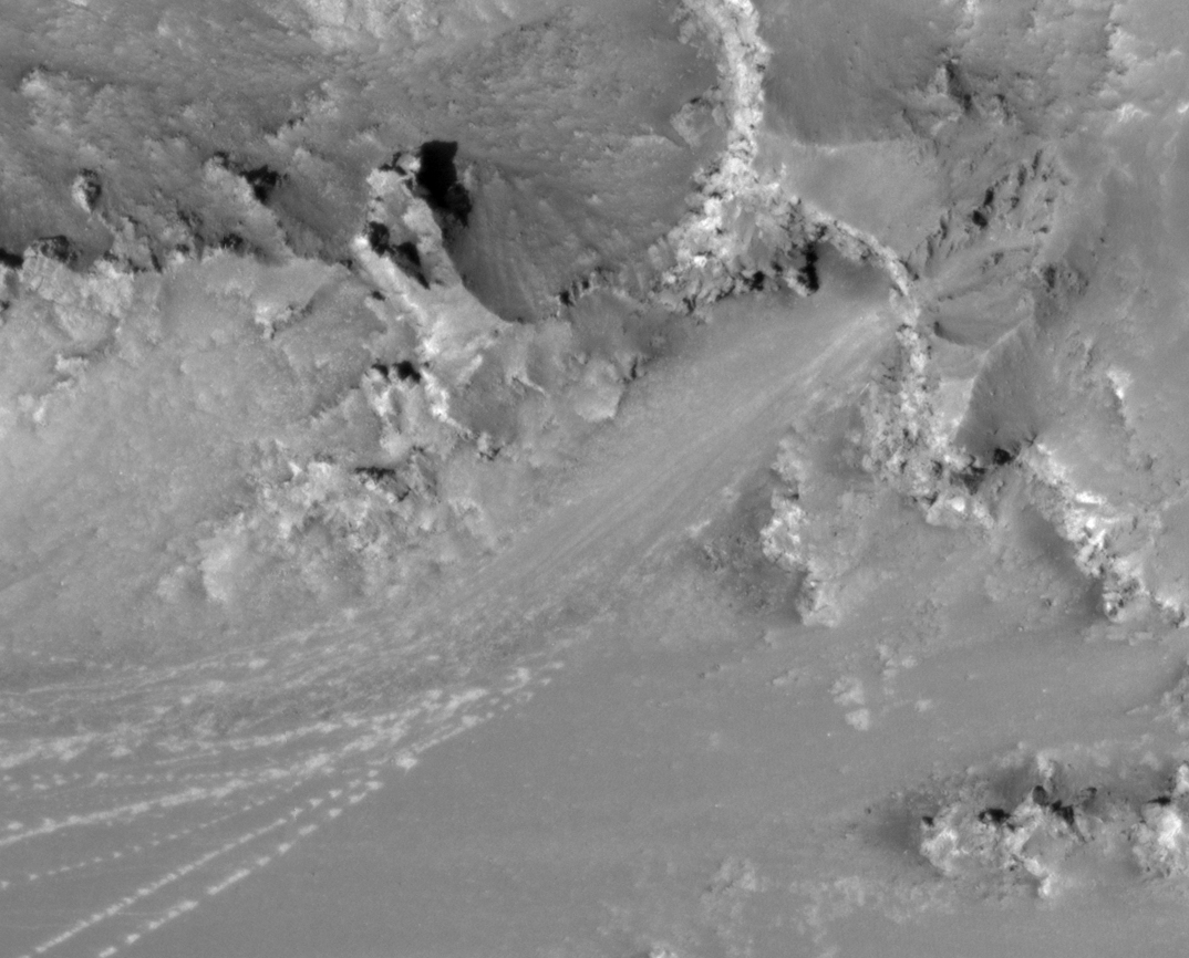
“The many boulder tracks in this image all seem to emanate from a small alcove near the rim of the crater,” describes HiRISE Targeting Specialist Nicole Baugh. “They spread out downslope and finally terminate near the crater floor. A high-contrast stretch of the area where the tracks stop shows lots of boulders, some still at the ends of the tracks.”

A rough estimate from the high-resolution imagery suggests some of these Mars boulders are over a meter wide. Future Mars astronauts beware: don’t camp out at the bottom of Martian hills! There’s no vegetation to hold big rocks in place or slow their speed. As previous observations of Mars “avalanches” suggest, weathering through the expansion of water ice (frost action) and/or rapid vaporization of carbon dioxide ice likely trigger pretty extreme downfalls of debris. It would be a bummer to travel all the way to Mars, survive the ravages of solar radiation, a daring descent and landing only to get flattened by a wayward chunk of rock when you set up camp.

I’ve always had a special joy for surveying HiRISE observations; it’s a very privileged window to this alien landscape that, in actuality, has many similar geological processes we find on Earth. And so here we have a collection of boulders that, somehow, became dislodged and stormed down from the rim of a crater. If we saw such an event in person, we might note the unnatural bounce these boulders have in the roughly one-third Earth gravity. But we’d also have to find shelter fast, as just like rolling boulders on Earth, those things will flatten you.

A Martian Storm Is Brewing

This nearly global mosaic of observations made by the Mars Color Imager on NASA's Mars Reconnaissance Orbiter on Nov. 18, 2012, shows a dust storm in Mars' southern hemisphere. Credit: NASA
This nearly global mosaic of observations made by the Mars Color Imager on NASA’s Mars Reconnaissance Orbiter on Nov. 18, 2012, shows a dust storm in Mars’ southern hemisphere. Credit: NASA

As the sols march on, NASA’s brand new nuclear-powered rover Curiosity has detected a dramatic change in its surrounding atmosphere. A once-clear vista of the distant rim of Gale Crater now looks smoggy — almost like the gray-brown-yellow stuff that hangs above Los Angeles on a hot summer’s day. So what’s causing this change in opacity?

As can be seen in the above global view of Mars, NASA’s Mars Reconnaissance Orbiter took a near-continuous observation of the planet on Nov. 18 with its Mars Color Imager. The mosaic has picked out an assortment of geographical features, but there’s one rather ominous atmospheric feature (white arrows) that grabbed the attention of Malin Space Science Systems’ Bruce Cantor.

A regional dust storm is brewing and Cantor first observed the storm on Nov. 10. He reported the detection to NASA’s Mars Exploration Rover team who manage Opportunity. Although the storm is over 800 miles from the tenacious rover, dust storms are of a concern for any solar powered surface mission, especially for a rover that has outlived its expected mission lifetime by several years. Opportunity’s solar panels are already covered in dust, so should there be an additional dip in sunlight due to a dusty atmosphere there could be an impact on its mission. Additional dust layers on the panels wouldn’t help either.

Opportunity does not have a weather station, but its cameras have detected a slight drop in atmospheric clarity. Curiosity, on the other hand, does have a weather station — called the Rover Environmental Monitoring Station (REMS) — and has been closely monitoring the atmospheric variability over the last few days, detecting a decreased air pressure and a slight rise in overnight low temperature. This is in addition to the dramatic loss in visibility. In short, it sounds like Curiosity can sense a storm in the air.

With the help of Emily Lakdawalla over at the Planetary Society, a nifty animation by Egorov Vitaly that highlights the change in visibility has been showcased:

Six Navcam images pointed toward the horizon taken over the course of Curiosity's time near Rocknest document changes in the transparency of the atmosphere.  NASA / JPL / Egorov Vitaly ("Zelenyikot")
Six Navcam images pointed toward the horizon taken over the course of Curiosity’s time near Rocknest document changes in the transparency of the atmosphere. NASA/JPL/ Egorov Vitaly (“Zelenyikot”)

“This is now a regional dust storm. It has covered a fairly extensive region with its dust haze, and it is in a part of the planet where some regional storms in the past have grown into global dust hazes,” said Rich Zurek, chief Mars scientist at NASA’s Jet Propulsion Laboratory, Pasadena, Calif. “For the first time since the Viking missions of the 1970s, we are studying a regional dust storm both from orbit and with a weather station on the surface.”

Now this is the cool bit. We currently have an armada of Mars orbiters, plus two generations of Mars rovers doing groundbreaking work on opposite sides of the red planet. We are in an unprecedented age of planetary exploration where a network of robots all work in concert to aid our understanding of how the planet works. In this case, local weather changes are being observed around two surface missions while corroborating data is being gathered hundreds of miles overhead.

From the NASA JPL press release:

Starting on Nov. 16, the Mars Climate Sounder instrument on the Mars Reconnaissance Orbiter detected a warming of the atmosphere at about 16 miles (25 kilometers) above the storm. Since then, the atmosphere in the region has warmed by about 45 degrees Fahrenheit (25 degrees Celsius). This is due to the dust absorbing sunlight at that height, so it indicates the dust is being lofted well above the surface and the winds are starting to create a dust haze over a broad region.

Warmer temperatures are seen not only in the dustier atmosphere in the south, but also in a hot spot near northern polar latitudes due to changes in the atmospheric circulation. Similar changes affect the pressure measured by Curiosity even though the dust haze is still far away.

We’re monitoring weather on another planet people! If that’s not mind-blowing, I don’t know what is.

Note: Apologies for the Astroengine.com hiatus, I’ve been somewhat distracted with writing duties at Discovery News and Al Jazeera English. If you’re ever wondering where I’ve disappeared to, check in on my Twitter feed, I tweet a lot!

The Funky Craters of Mars

A menagerie of strange divots (NASA/HiRISE/Univ. of Arizona)

As 2011 draws to a close, it’s time to reflect on my absenteeism from Astroengine. But it’s not my fault, I’ve been typing like a madman for these guys.

But that’s enough excuses, 2012 promises to be a huge year for space, and if I get my time management skills back up to scratch, there will be a whole lot more of the blogging thing going on over here too. So to kick things off I thought I’d share a cool slide show I’ve been working on for Discovery News with Ari Espinoza of the High-Resolution Imaging Science Experiment (HiRISE) — the awesome camera currently orbiting Mars aboard NASA’s Mars Reconnaissance Orbiter (MRO).

With the help of Ari, we managed to collect some weird-looking Mars craters (for the hell of it) and create a slide show with some of the strangest. Below are a few of my favorites, but be sure to check out the full slide show for more oddities!

Rolling (Mars) Stone

The 6 meter-wide boulder as imaged by HiRISE (to supersize the pic, click on it - 9MB)

It may only be a large rock, but images like this drive home the significance of the HiRISE instrument on board NASA’s Mars Reconnaissance Orbiter; it enables us to see recent geological activity on a planet we often view as being “dead.”

This boulder (approximately 6 meters-wide) had come to a stop at the bottom of the sloping wall of an impact crater. The path the boulder took is obvious as it left a series of prints in the Martian regolith as it bounced and rolled. The darker material that appears to have flowed around the rock is relatively fresh dry dust and sand that has also been dislodged from the top of the slope, falling as an avalanche, settling as a dark streak. As time goes on, the streak will age and blend in with the surrounding regolith.

It is suspected that seismic activity or a weather event (such as a dust devil) may have triggered the avalanche. As for the boulder, it looks like it rolled down the slope before the sand/dust avalanche, so it may have originated from the same destabilization event, or it happened earlier. As the source of the streak and boulder appear to originate from the same location, I suspect the former might be the case.

Regardless, it goes to show Mars is still active, and the MRO is in the perfect location to capture the Red Planet proving that fact.

Source: HiRISE

Mars Can Be A Fuzzy Planet

The summit of Pavonis Mons (NASA)

This strange image was captured by the Mars Reconnaissance Orbiter’s (MRO) camera–the amazing High Resolution Imaging Science Experiment (HiRISE)–as it passed over one of the largest volcanoes in the Solar System, Pavonis Mons.

Located near the equator of Mars, atop the Tharsis bulge, Pavonis Mons is the second highest volcano after the huge Olympus Mons (towering over the Martian surface 27 km high). Pavonis Mons is still much higher than anything the Earth can muster, towering 14km into the atmosphere (compare that with the altitude of Mt. Everest’s peak height of 8.85 km).

So why is this picture so blurry? Is HiRISE suffering a malfunction? Did mission control send the wrong commands? Actually, HiRISE is working just fine. It’s the dust-covered surface that’s blurred.

As the ancient volcano is reaching so high into the Martian atmosphere, the air becomes very thin. The atmosphere was already thin; the average ground level atmospheric pressure is less than 1% of the Earth’s. At Pavonis Mons’ peak, the atmospheric pressure is ten-times thinner. Therefore any wind at these altitudes is extremely weak.

The extreme planet-wide dust storms that regularly engulf Mars dump huge quantities of dust on the top of the Martian volcanoes, but when the dust settles, there’s nothing to transport it elsewhere. Therefore, the thick layer of fine material remains where it is, tickled by the light-weight winds, rarely moving.

In the high resolution image, you can see some resolved features such as the odd impact crater and small ripples. Other than that, it’s a thick, smooth dust blanket that covers the Pavonis Mons summit, hiding any interesting geology for below, giving the impression any images of the summit are out of focus…

For more, check out The Blurry Summit of Mars’ Pavonis Mons on the Universe Today.

Welcome to my Sinkhole, Premium Martian Real Estate

A sinkhole in Tractus Fossae, created by tectonic activity (HiRISE/NASA)

It might not look like much from space, but this depression in the Martian landscape might be considered to be a priceless feature when viewed by future Mars colonists.

In December 2008, the Mars Reconnaissance Orbiter (MRO) flew silently over the Tharsis bulge, the location of a series of ancient volcanoes. The High Resolution Imaging Science Experiment (HiRISE) captured what appears to be a deep hole. This kind of feature has been seen before, like a Martian pore, deep and foreboding. Usually these sinkholes aren’t as deep as they look, but they are deeper than the surrounding landscape. They are also similar to their terrestrial counterparts in that they have very steep sides (unlike the gentle, eroded slopes of crater rims) and they are caused by a lack of material below. On Earth, sinkholes often form due to water flowing beneath, removing material, causing the overlying rock/soil to slump, forming a sudden hole. In the example above, the sinkhole (or “collapse pit”) was caused by tectonic activity. In this case, it is likely that the material dropped into a void left over by magma-filled dykes (lava tubes from old volcanoes).

A stretched and image processed version of the sinkhole; the bottom of the hole is visible (HiRISE/NASA)

The result is a hole with very steep sides. It has been suggested that these sink holes may be useful to future Mars colonists, as they can use the natural feature for shelter. On Mars, humans would be subject to an increased dosage of radiation (due to the tenuous Martian atmosphere and lack of a global magnetic field), so it is preferable to find any form of natural shelter to build your habitat. The depth of this kind of sinkhole will afford some protection, and drilling into the cavern side would be even better. Perhaps even put a dome over the top? No need to build walls around your building then. Also, there’s the interesting–if a little frightening–prospect of accessing underground lava tubes. Therefore, colonists won’t need to dig very far to create a subterranean habitat with all the radiation protection they’ll ever need (the insulation would also be impressive).

Although this scenario might be a little far-fetched, and probably only suitable for an established human presence on Mars (after all, the numerous valleys would probably suffice for most permanent habitats drilled into cliff faces), it does go to show that the current missions in orbit around Mars are doing a great job at seeking out some possible housing solutions for our future Mars settlers…

Source: HiRISE, Marspedia

When Cosmic Rays Attack: The MRO in Safe Mode

mars_reconnaissance_orbiter21

I always get concerned when I hear about one of our invaluable robotic explorers switching into safe mode. This time, it is the turn of NASA’s Mars Reconnaissance Orbiter (MRO) that re-booted itself after an “event” in Mars orbit. It seems likely that a direct cosmic ray hit could be to blame…
Continue reading “When Cosmic Rays Attack: The MRO in Safe Mode”

Mars Gets Hit By Cosmic Buckshot

Bolide breakup and impact on the surface of Mars (HiRISE/NASA)

Earth has been hit numerous times in recent months by some large chunks of space rock. One of the larger meteoroids to enter the atmosphere was the November fireball over Saskatchewan, Canada. In this case, an estimated 10 tonne meteorite slammed into the atmosphere, creating a bright bolide (fireball), exploding into fragments. Fortunately, eyewitnesses were able to pinpoint the location of possible debris. Sure enough, after an extensive search in the rural area of Canada, meteorite fragments were found.

However, these fragments did not impact the ground at the hyper-velocities that the original fireball was travelling at, the Earth’s thick atmosphere created an efficient barrier, through air resistance, breaking up the bolide. In this case, an energetic explosion was observed for miles around. Fragments from the fireball then fell at a maximum speed of terminal velocity, bouncing off the ground. Some fragments sat proudly on top of frozen ponds – the debris final kinetic energy was so low that little damage would have been done even if the small rocks scattered over a populated area (unless, of course, someone got hit on the head – they would have had a very bad day).

OK, so we’re well protected from most bits of junk space can throw at us. Most meteoroids, from the size of a grain of sand to the size of a small bus, will burn-up, break-up or explode high in the atmosphere, scattering bits on the ground. But what about Mars? What if Mars gets hit by a sufficiently-sized meteoroid?

Even if the meteoroid does break apart, unfortunately the atmosphere is too thin to slow the debris sufficiently. A lack of air resistance makes for more impressive impact craters. Watch your heads future Mars colonists, you could be faced with a shotgun blast from space
Continue reading “Mars Gets Hit By Cosmic Buckshot”

Frosty Phoenix Not Snowed Under… Yet.

The Mars Reconnaissance Orbiter's HiRISE instrument spots the dead Phoenix Lander on December 21st (NASA/HiRISE)

NASA lost contact with the Phoenix Mars Lander at the start of November 2008, as its batteries were drained and sunlight began to dwindle. With no sunlight came no charge for the batteries from Phoenix’s solar panels, and the robot’s fate was sealed: a sun-deprived coma. A dust storm hastened the lander’s fate, but it certainly wasn’t premature. The Phoenix mission was intended to last three months, but in the same vein as the Mars Exploration Rovers, Phoenix’s mission was extended. In the high latitude location of the Martian Arctic, a dark winter was fast approaching, so Phoenix didn’t have the luxury of time and it transmitted its last broken signal before the cold set in, sapping the last volt of electricity from its circuits…

Although there was some excitement about the possibility of reviving the lander next summer, it is highly unlikely Phoenix will be in an operational state, even if it did have an abundant source of light to heat up its solar panels once more. No, Phoenix is dead.

However, that doesn’t mean the orbiting satellites won’t be looking out for it. So long as there is a little bit of light bouncing off the frosted Martian surface, the Mars Reconnaissance Orbiter can image Phoenix, keeping track of the encroaching ice around its location. The HiRISE team seem to be assembling a series of images throughout the change in seasons at the landing site, so it will be interesting to see the full set…

Source: HiRISE blog

HiRISE Mars Digital Elevation Models: Difficult to Build, Easy on the Eye

DEM images of Columbia Hills on Mars (USGS/HiRISE)

If there’s one instrument that should get the Mars Orbiting Science Award of 2008 it’s the High Resolution Imaging Science Experiment (HiRISE). Flying on board NASA’s Mars Reconnaissance Orbiter (MRO), HiRISE has been taking some astonishing imagery of the Martian surface since 2006. In fact, the HiRISE image gallery has become the staple of my high resolution Mars photo collection, and the studies being carried out by this fantastic instrument have formed the basis of many articles.

However, the most useful images to come from HiRISE are also the rarest. Digital Elevation Models (DEMs) come from the use of stereo image pairs (more commonly seen in anaglyphs generated by the HiRISE team to give the viewer a 3D impression of the Martian landscape). In the case of DEMs, some pretty neat science can be done, generating images of the Red Planet’s terrain in unrivalled precision. Seeing the Victoria Crater DEM is a particular joy
Continue reading “HiRISE Mars Digital Elevation Models: Difficult to Build, Easy on the Eye”