")
If there’s one instrument that should get the Mars Orbiting Science Award of 2008 it’s the High Resolution Imaging Science Experiment (HiRISE). Flying on board NASA’s Mars Reconnaissance Orbiter (MRO), HiRISE has been taking some astonishing imagery of the Martian surface since 2006. In fact, the HiRISE image gallery has become the staple of my high resolution Mars photo collection, and the studies being carried out by this fantastic instrument have formed the basis of many articles.
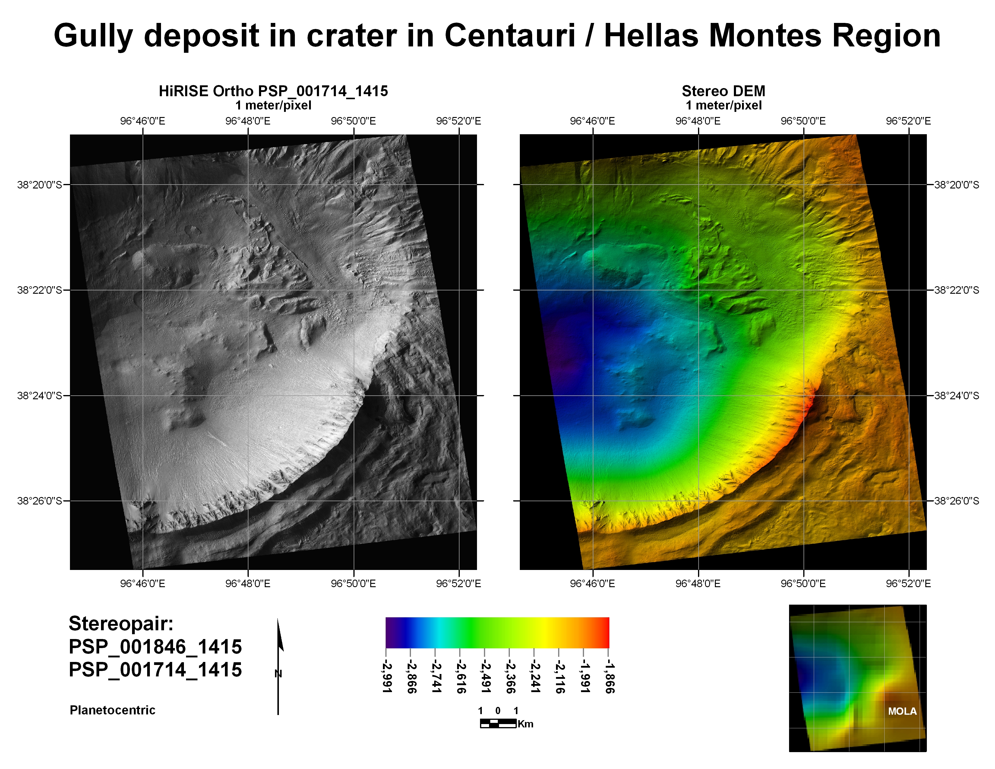
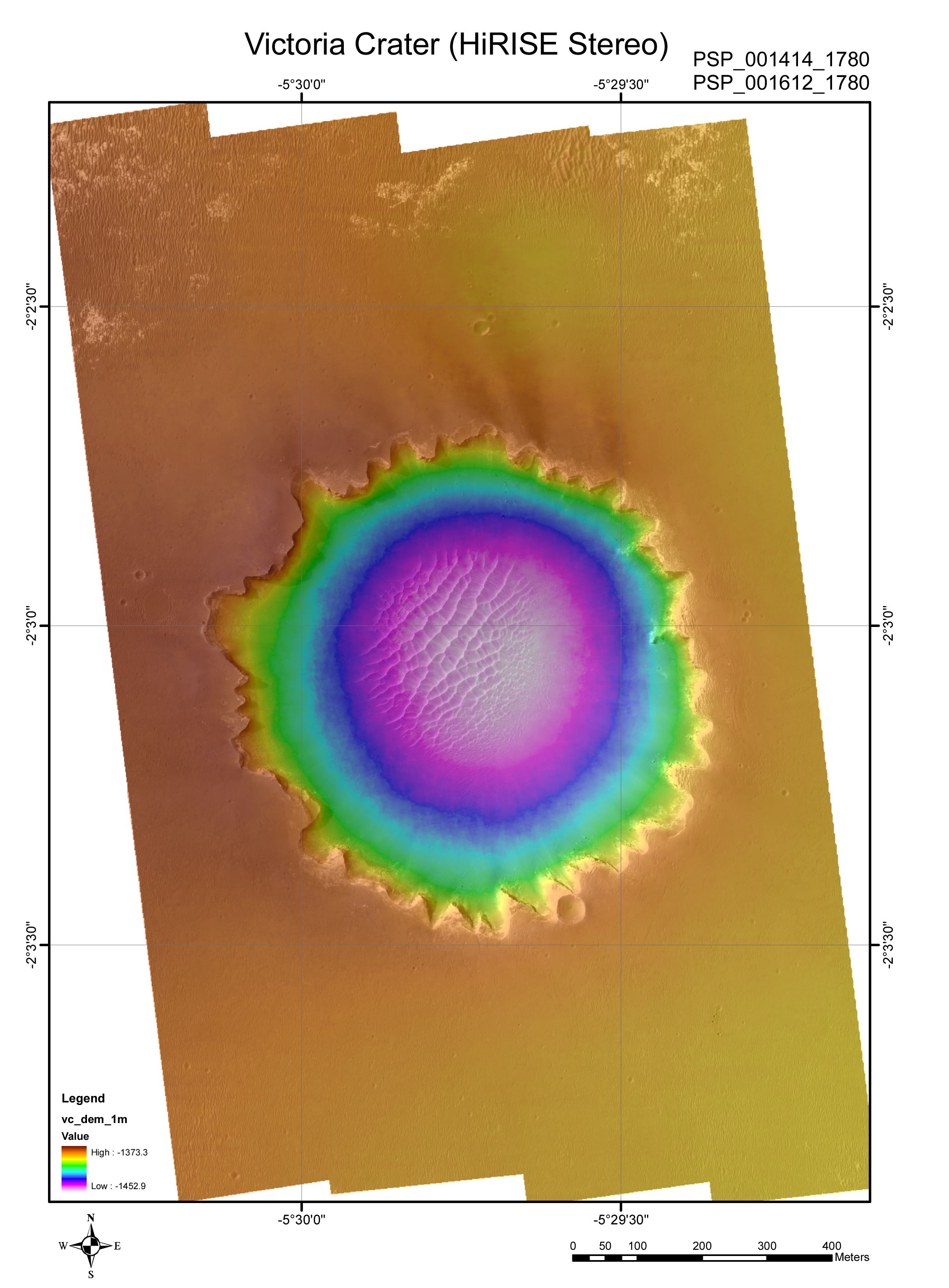
However, the most useful images to come from HiRISE are also the rarest. Digital Elevation Models (DEMs) come from the use of stereo image pairs (more commonly seen in anaglyphs generated by the HiRISE team to give the viewer a 3D impression of the Martian landscape). In the case of DEMs, some pretty neat science can be done, generating images of the Red Planet’s terrain in unrivalled precision. Seeing the Victoria Crater DEM is a particular joy…
Why are DEMs awesome? I’ll let HiRISE blogger Percy from the University of Arizona explain:
A DEM, if you don’t already know, is a digital elevation model. This is a product that can also be produced from a HiRISE stereo pair. HiRISE DEMs are awesome because they can model the terrain at a resolution of 1 meter per post! That means for every square meter of Mars visible in a HiRISE image (for which we have stereo) we can derive an elevation value. This provides the opportunities to measure geological features, model hydrology and spacecraft traverses.
HiRISE is able to image the Martian surface with unrivalled resolution. In fact, it challenges the resolution of most Earth-observing cameras:
The High Resolution Imaging Science Experiment camera is a 0.5 m reflecting telescope, the largest ever carried on a deep space mission, and has a resolution of 1 microradian (μrad), or 0.3 m from an altitude of 300 km. In comparison, satellite images of Earth are generally available with a resolution of 0.5 m, and satellite images on Google Maps are available to 1 m.[24] HiRISE collects images in three color bands, 400 to 600 nm (blue-green or B-G), 550 to 850 nm (red) and 800 to 1,000 nm (near infrared or NIR). — Wikipedia
So, by generating a DEM, a colour-coded relief map can be produced. This technique allows scientists to distinguish between surface features and gauge slight altitude variations. Looking at some of the examples below, I find the terrain to be strikingly varied; altitude variation often gets lost when just looking down on the 2D landscape. DEMs make the landscape easily identifiable, improving identification of crater depth, mesa height and canyon detail. For me, the most striking image is that of Victoria Crater, a location where MER Opportunity had a good look around at the start of 2008.
Although DEMs from HiRISE data are extremely useful, they are notoriously difficult to generate. Fortunately the US Geological Survey Astrogeology group is on the scene to help, producing DEMs for use in Mars Science Laboratory (MSL) landing site selection workshops. The HiRISE team is hopeful more DEMs will be rolled out with future images of the Martian relief from 300km above, so the science can only get better.
For now, I’ll leave you with some DEM relief maps of Mars. If you want to see more, check the USGS website, it’s well worth the look. I hope a HiRISE DEM of the Olympus Mons caldera will be available soon…

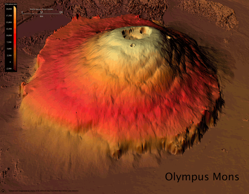
Update: From older MOLA data (NASA’s Mars Orbiter Laser Altimeter on board the Mars Global Surveyor), a DEM of Olympus Mons generated a rather nice 3D image of the old volcano, shown below:
")
Source: HiRISE blog

I love these maps.
I love these maps.very beautiful!
Hellow!
I love your site, It is a pleasure to visit.
I have added your site to my site.
Please link my site to your site.
Thank you!
http://personalnewshobby.blogspot.com/